Accessible Pedestrian Routing Tools Expand to Three Washington Cities
Whether navigating urban spaces with different abilities, or simply seeking a walking or biking path that prioritizes specifications other than the quickest route and shortest distance, having access to standardized, comprehensive data about pedestrian pathways offers wide-ranging benefits.
However, this information is often difficult to find due to local variations in data collection, inconsistencies and limited data, and the prioritization of data on streets and cars rather than sidewalks and pedestrians in transportation network analyses and routing apps.
Dr. Anat Caspi, director of the Taskar Center for Accessible Technology at the University of Washington (UW), leads an effort to establish consistent, detailed standards for tracking data about pedestrian paths and their connectivity within multimodal transportation networks, locally and beyond. Since 2015, Caspi and Nick Bolten, a Postdoctoral fellow in the Paul G. Allen School of Computer Science & Engineering, have been working with stakeholders on the OpenSidewalks project to improve the collection, organization and sharing of data on the built environment to promote equity and inclusivity in transportation. They track features such as curb ramps, accessible traffic lights, elevation changes and sidewalk quality, width and shoring, which are often omitted from transportation network data and routing apps.
Using this data, Caspi and Bolten developed AccessMap, a web application launched in 2017 that provides customized routing directions for pedestrians based on individual mobility profiles. The maps are available for three Washington cities: Seattle, Bellingham and Mount Vernon, where they have received over 35,000 routing requests. Expansion is underway, with data collection in progress in Austin, Texas and San Jose, California, and potential partners in Portland, Oregon.
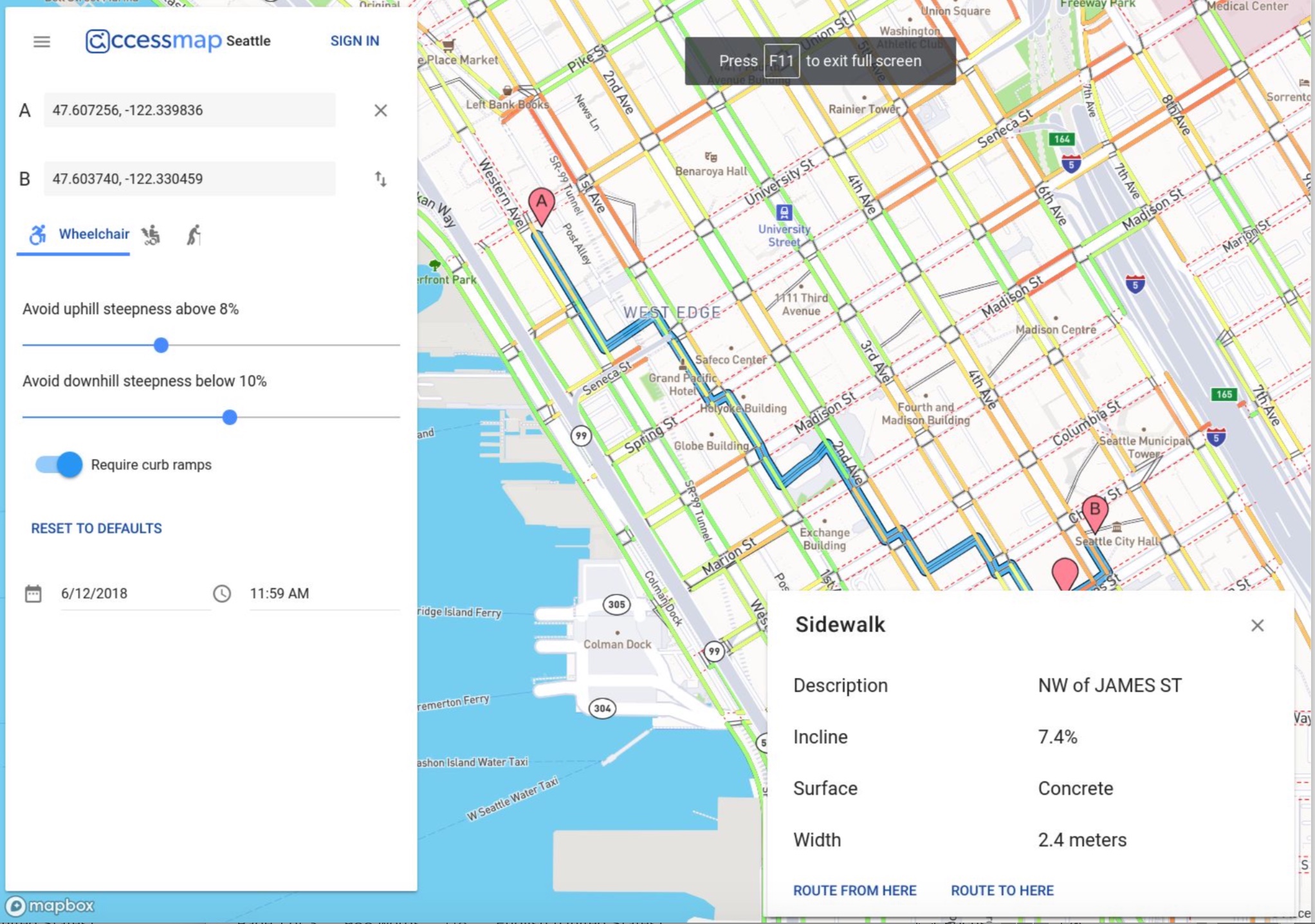
Designed with user research, AccessMap provides directions for several starting mobility profiles (use of a manual wheelchair, power wheelchair, or cane), but enables each user to further dial in their specific attributes, allowing for variation within the same canonical device-user mode. Travelers can specify preferences such as requiring lowered curbs or avoiding up or down hills above a certain percentage grade. Sidewalk surface type, steepness and width are provided when available. AccessMap incorporates accessibility information from multiple sources, along with time-of-day traffic patterns, although it does not include sidewalk closures due to construction, or real-time transit and congestion data. To protect user privacy, personal preferences are not transmitted to the application’s cloud, and imagery data is analyzed for path information only, and is not published or stored long-term.
Together, these analytic tools support accessible route planning and active transportation at the individual level, and equity and access in civic planning at the agency level. “In order to satisfy equity and accessibility concerns, we require a connected graph to describe how paths connect on the ground rather than just path assets,” Caspi explained at a May 2020 webinar hosted by the Washington State Department of Transportation (WSDOT). “Planners need to be armed with these tools and information in order to quantify and illustrate at a whole city scale the potential impacts of streets on populations, on job centers, residential areas and beyond that,” she said. The presentation, titled “OpenSidewalks and Resilient Cities: Pedestrian-Centric Approach,” can be viewed here.
WSDOT has been an early partner since OpenSidewalks began as a project in the Data Science for Social Good program at the UW eScience Institute, led by Caspi and Bolten, in 2015. Since then, the standards created for AccessMap have been incorporated by several regional entities. For example, Caspi is partnering with MV Transit, the paratransit operator for King County Metro, to organize its sidewalk data in a common format across the region, and to jointly develop an app to collect compliance data in relation to the Americans with Disabilities Act. The coronavirus pandemic has further highlighted the importance of sidewalk data, as knowing the width of a walkway is helpful for social distancing.
As a researcher with the UW Urbanalytics unit, where OpenSidewalks is an affiliate project in the Equitable Transportation category, Caspi is also part of a larger movement of researchers and technologists using data science and technical methods to generate new tools to measure transit patterns and inform planning efforts. Efforts are underway to expand this work to promote transportation equity and data inclusivity at the national scale by incorporating data on accessible transit and travelers with disabilities into the daily collection of ridership data, establishing an interoperable infrastructure to collect and analyze privacy-protected transportation data, and facilitating performance metrics to improve transit providers’ ability to measure access to transportation.
Caspi advocates for a shift away from common methods of collecting transportation network data that focus on the numbers of cars and crashes, with sidewalks recorded simply as present or absent, to treating sidewalks and pedestrian paths as their own complex entities. Infrastructure information, when available, is often insufficient for establishing a complete path for routing. As a result, “Routing directions often ignore the initial or final segments of travel,” she notes. For cities that already collect detailed data on sidewalks, “their use is limited by lack of universal standards with other places.” Adopting standardized formats would enable the collection of mobility data across different regions and eliminate the need to manually clean and collate data sources, Caspi explains.
Data for OpenSidewalks is collected in multiple ways. Computer vision is used to collect data on infrastructure, the environment and path connections. Data for the Mount Vernon map was collected entirely by crowdsourcing, while data on Bellingham was imported from city data sets. AccessMap uses open source code and shares data with OpenStreetMap, a collaboratively edited map of the world.
Caspi’s work on accessible transportation is also expanding through the Center for Research and Education on Accessible Technology and Experiences (CREATE), launched in May 2020 with an initial $2.5 million investment by Microsoft. The mission is to “make technology accessible and to make the world accessible through technology.” Caspi is the Director of Translation and one of nine faculty members leading the effort that will expand ongoing work in accessible transportation, inclusive design, augmenting abilities through wearable technologies, and more.